Thousands of Resources, Ready to help.
Advantages
Popular

2026 Michigan Archaeology Poster
By Air, Water, and Land: Archaeology & Geophysical Technology
What a stunning coastal landscape! What archaeological stories could possibly be buried just beneath the surface or waves? Today’s archaeologists don’t just use trowels and shovels to find archaeological sites! Modern archaeology includes a variety of advanced technology, tools, and equipment to inform us about human activities in the past.
This year's poster explores these different technologies, including imagery from Fort Gratiot Lighthouse (Michigan's oldest) and other archaeological discoveries. A limited number of posters were printed for Michigan Archaeology Day and other 2026 events.
Archaeology is the study of human history by investigating the material remains, objects, and buildings we create and use.
Archaeology can make the history of a place tangible and connect us to people who once walked in the same places we step today. Traces of the past may often quite literally be buried beneath our feet, even in places where no evidence remains on the surface. While the landscape may transform and change, there can still be archaeological deposits intact, revealing the stories of those who lived there before us.
The same is true on the water. Water, particularly the cold fresh water of the Great Lakes, is a highly functional preservation environment. For generations, the Great Lakes have served as the super highways of this region, and evidence of this tangible history remains intact on the lakebed. The Great Lakes and Great Lakes Shipping are a fundamental part of Michigan's history. Maritime archaeologists explore submerged sites such as shipwrecks, helping us learn about those who sailed across our inland seas before us by studying what objects remain.
This year's poster and webpage explore geophysical archaeology. Geophysical technology allows archaeologists to see below the ground, without digging, and below the water, without diving, as it is a non-invasive technology. Most conventional archaeological methods are destructive, once the soil or sediments have been removed, it cannot simply be put back to the way it was.
Archaeologists use non-invasive geophysical technology because it allows them to investigate what lies beneath the ground, or underwater, without digging or disturbing archaeological sites. These methods help preserve culturally sensitive sites and features while providing valuable information about the location, size, and layout of buried structures.
Archaeologists use several types of geophysical survey technologies. Each method measures a different physical property.
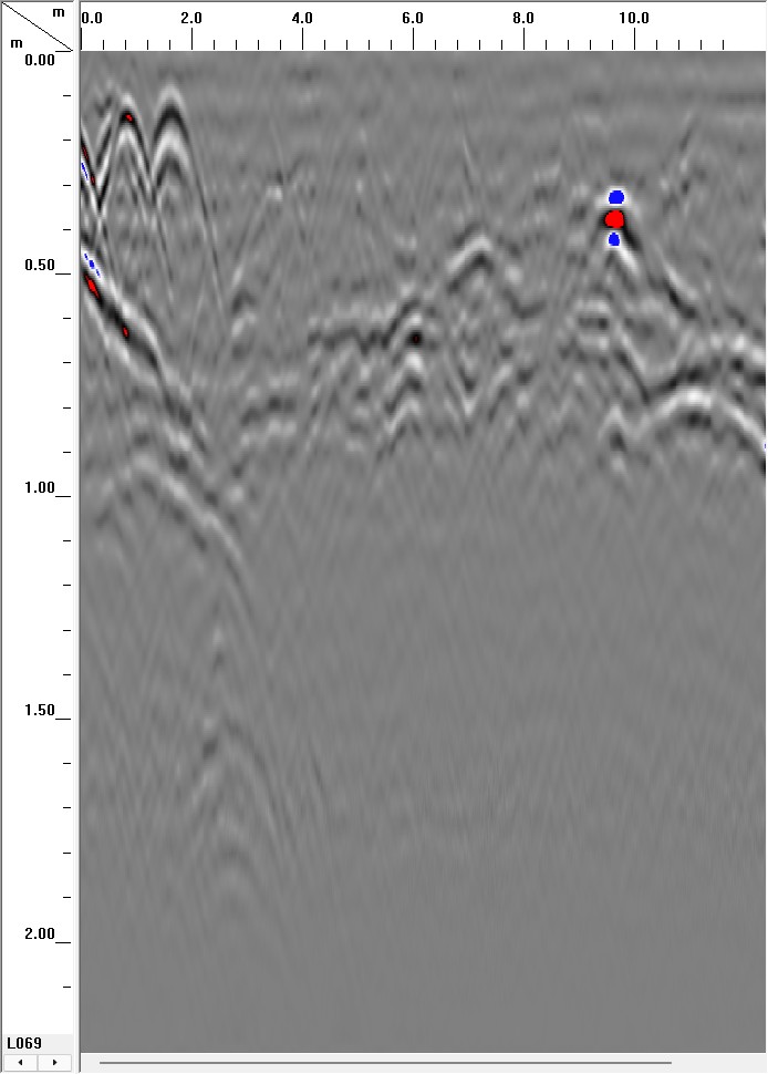
LAND: Ground-Penetrating Radar (GPR)
• Sends high-frequency radio waves into the ground.
• Measures the echoes that bounce back from buried objects or soil layers.
• Produces 2-dimensional profiles and 3-dimensional images of subsurface features.
• Best for finding:
◦ Foundations and buried structures
◦ Graves
• Measures tiny changes in the Earth’s magnetic field caused by buried archaeological remains.
• Very fast and can survey large areas.
• Best for detecting:
◦ Hearths and fired bricks
◦ Ancient buildings
◦ Submerged anchors
• Measures how easily soil becomes magnetized.
• Helps locate areas with evidence of human occupation, such as:
◦ Ancient settlements
◦ Fire pits
◦ Waste disposal areas
Discovery of the 1881 Michigan State University Observatory
• In 2023, MSU employees were installing hammock posts near student residence halls when they encountered an impenetrable surface under the ground.
• Believing it to be either a large rock or building foundation, MSU’s Campus Archaeology Program (CAP) was consulted.
• After cross-checking old maps, campus archaeologists determined that it was the foundation of the first observatory on MSU’s campus, constructed in 1881.
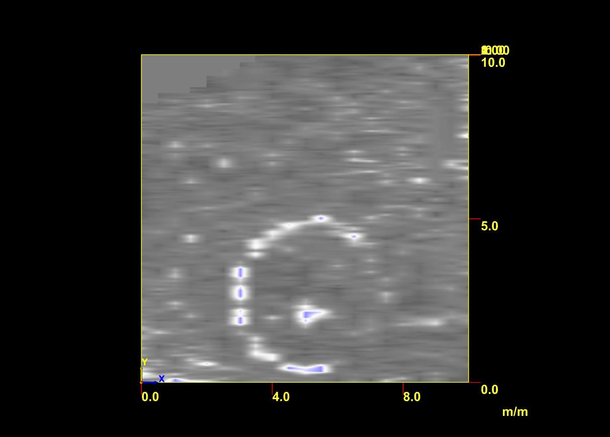
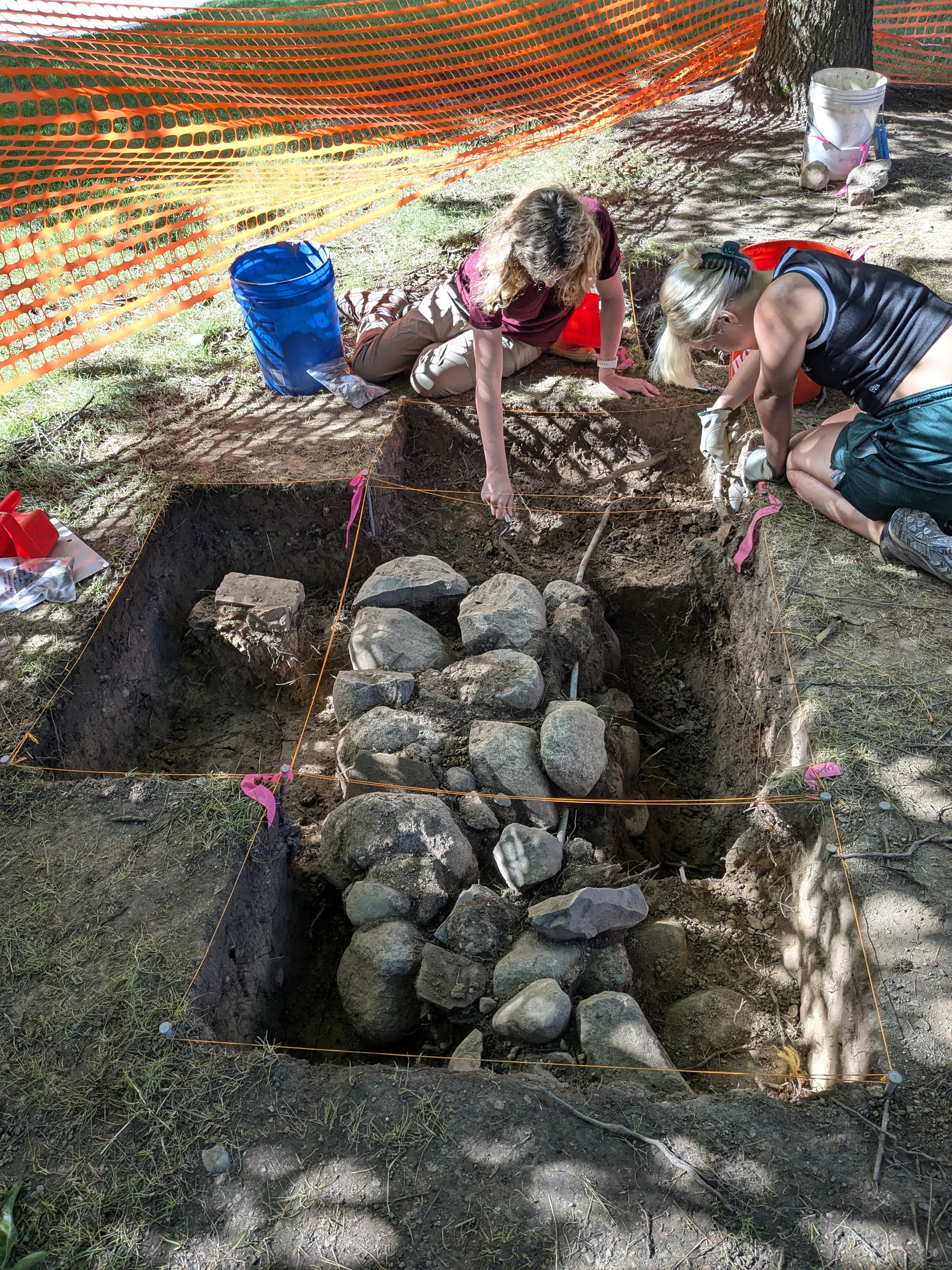
• This provided a living labratory for archaeological discovery on campus, as the circular foundation was studied in several ways.
• Portions of the stone foundation were systematically excavated, as seen in the following photo.
• The entire area was mapped with Magnetrometry, with the circular foundation clearly visible in the results.
Who would have thought one of MSU's first science facilities - an observatory meant to observe the sky - would become a living labratory for a completely different field of science - archaeology - well over a century later? The MSU observatory was built in 1881, but was torn down in the 1920s. Over time, its exact location was forgotten, until now. Learn more about the rediscovery.
Water
Underwater Archaeologists also use geophysical technology to see below the water. Magnetometers and metal detectors can be used to locate sites/objects underwater. Sonar is a common geophysical technology used by underwater archaeologists. Sonar makes finding, and exploring, shipwrecks easier. Sonar devices can either be pulled by a boat, or can be mounted to autonimous vehicles that scan a prescribed area.
• Emits sound waves that bounce off the lake bottom
• Measures the acoustic wave’s speed and density
• Creates highly detailed, 2-dimensional visual of underwater features, including:
◦ Shipwrecks
◦ Aircraft wrecks
◦ Submerged structures
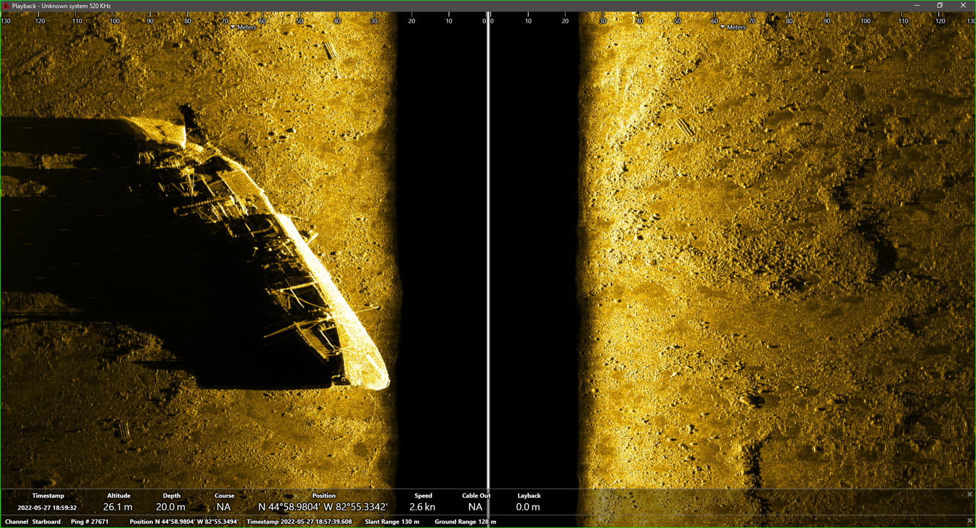
The ocean-going freighter Monrovia sank in Lake Huron near Alpena in 1959. It has been extensively documented using side scan sonar and other methods.
• Emits a fan-shaped swath of sound waves downward to map the lake floor
• Calculates how long the acoustic pings take to bounce back
• Generates a 3-dimensional bathymetry and detailed images, including:
◦ Underwater landscape features
◦ Submerged cultural resources
Recently, a multibeam sonar vessel mapped the lakebed under a large area of the Straits of Mackinac and areas around Mackinac Island.
The Great Lakes have been superhighways for millenia. As many as 6,000 ships have been lost on the Great Lakes, including an estimated 1,500 in Michigan waters. The preservation of shipwrecks is important so archaeologists can better understand the lifeway of the people who built, operated, and went down with the ship. The Monrovia, an ocean-going ship that sank in Lake Huron near Alpena in 1959, has been extensively studied using side scan sonar.
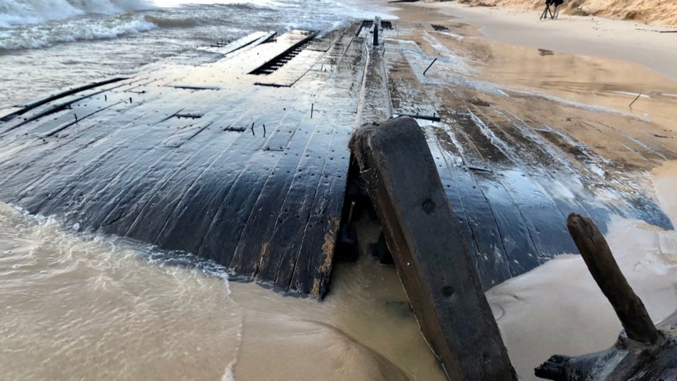
You're walking along the beach and
Wait, is that part of a shipwreck?
As the Great Lakes shores erode and lake levels change, historic sites including shipwrecks, parts of historic vessels, artifacts, abandoned docks, pilings, maritime landscapes, and prehistoric objects may be exposed. Members of the public and citizen scientists can report such finds to the State of Michigan. Information submitted will be included in the State Archaeological Site File, the official record of terrestrial and bottomland archaeological sites in Michigan.
To prevent damage to historic sites, investigate the find only with your eyes and leave all artifacts in place. Document the find with photographs, sketches, maps, and GPS coordinates.
In Michigan, there are both National and State laws that aim to protect shipwrecks and other submerged sites. The Abandoned Shipwreck Act of 1987 is a Federal law that recognizes the importance of shipwrecks as cultural sites. The U.S. Submerged Lands Act of 1953 establishes that states manage submerged cultural sites on state bottomlands.
It is important to recognize that while not all shipwrecks are grave sites, many are and continue to be final resting places, including the Edmund Fitzgerald.
Archaeological investigations of shipwrecks in Michigan waters require a permit from the Department of Natural Resources. Part 761 of the Michigan Aboriginal Records and Antiquities Act prohibits the removal, alteration and destruction of shipwrecks or associated artifacts. While diving on shipwrecks is allowed under State and Federal law, it is illegal to move or recover objects or artifacts from shipwrecks in Michigan. Part 761 also prohibits removal or defacing of any human remains associated with shipwrecks. In Canadian waters, laws including the Wrecked, Abandoned or Hazardous Vessels Act and the Ontario Heritage Act, R.S.O. 1990 protect shipwrecks with historical or archaeological value, requiring a permit for any individual to dive on cultural resources. Failure to secure a diving permit could result in a $1 million fine.
Why Shipwreck Preservation is Important
Submerged cultural resources, like shipwrecks, provide a unique glimpse into the past. Naturally preserved by the cold, freshwaters of the Great Lakes, shipwrecks are often a snapshot of a moment in time. Archaeologists can learn about past human behavior by studying these preserved moments. Preservation of shipwrecks, such as the Edmund Fitzgerald or the wooden freighter Joseph S. Fay pictured here, is important so archaeologists can better understand the lifeway of the people who built, operated, and went down with the ship. Questions about maritime history including shipbuilding, technology, navigation, and trade can be addressed by underwater archaeologists. Damaging or removing parts of sunken ships changes the context of the site and therefore alters the story that can be learned.
Every November, remembrance ceremonies are hosted at several places around the Great Lakes to honor those lost in shipwrecks. An annual ceremony is held on November 10th at the Great Lakes Shipwreck Museum at Whitefish Point where a bell is rung 29 times, once in honor of each crew member lost on the Edmund Fitzgerald.
29 Bells: Edmund Fitzgerald crew manifest
Click HereArchaeology 101
Michigan Archaeology Day | Michigan History Center
Michigan State Historic Preservation Office (SHPO)
Archaeology Program | Michigan SHPO
Michigan Archaeology Month | Michigan SHPO
Archaeology Laws | U.S. National Park Service
National Historic Preservation Act of 1966 | U.S. National Park Service
Underwater Archeology | U.S. National Park Service
Edmund Fitzgerald Collection | Detroit Historical Society
Edmund Fitzgerald | Great Lakes Shipwreck Historical Society
The Fateful Journey | Great Lakes Shipwreck Historical Society
MarineTraffic.com | Track ships across the Great Lakes
Remembering the Edmund Fitzgerald | National Museum of the Great Lakes
Mapping the Edmund Fitzgerald final voyage StoryMap | National Weather Service
"The Seas are Tremendously Large" Radio dialogue from the search for the Edmund Fitzgerald | YouTube
S.S. Edmund Fitzgerald Online
Michigan Shipwrecks | Michigan History Center
Michigan Shipwrecks StoryMap | Michigan Department of Natural Resources
Michigan Shipwrecks | Environment, Great Lakes, and Energy
Shipwrecks FAQ| Environment, Great Lakes, and Energy
Abandoned Shipwreck Act of 1987 | U.S. National Park Service
Abandoned Shipwreck Act Guidelines | U.S. National Park Service
Submerged Lands Act (SLA) of 1953
Michigan Underwater Preserves
Thunder Bay National Marine Sanctuary
The Edmund Fitzgerald, and thousands of other shipwrecks, illustrate snapshots in Michigan's rich history. They are places to be admired, but also respected. Archaeological sites are nonrenewable. Once gone, they are gone forever. Treat every site with care and respect, and with their preservation for the good of future generations in mind.
We offer our thanks to the Detroit Historical Society and Great Lakes Shipwreck Historical Society for sharing their image collections with us for this project, and to John Wellman for the original artwork of the Edmund Fitzgerald.
As the largest vessel on the Great Lakes at the time of construction, the “Fitz” became the flagship of Cleveland-based Columbia Transportation Company and made regular round trips between the Lake Superior iron range and Detroit, Toledo, or Cleveland. This massive vessel set several cargo records during its sailing career and was a favorite among boat watchers. Tragically, after 17 years on the Great Lakes, the Fitzgerald got caught in a ferocious storm on Lake Superior and sank on November 10, 1975. All 29 crew members perished, devastating the lives of their families, friends, and fellow sailors. The location of the wreck was positively identified in May 1976.