Thousands of Resources, Ready to help.
Advantages
Popular

2026 Michigan Archaeology Poster
By Air, Water, and Land: Archaeology & Geophysical Technology
What a stunning coastal landscape! What archaeological stories could possibly be buried just beneath the surface or waves? Today’s archaeologists don’t just use trowels and shovels to find archaeological sites! Modern archaeology includes a variety of advanced technology, tools, and equipment to inform us about human activities in the past.
This year's poster explores these different technologies, including imagery from Fort Gratiot Lighthouse (Michigan's oldest) and other archaeological discoveries. A limited number of posters were printed for Michigan Archaeology Day and other 2026 events.
Archaeology is the study of human history by investigating the material remains, objects, and buildings we create and use.
Archaeology can make the history of a place tangible and connect us to people who once walked in the same places we step today. Traces of the past may often quite literally be buried beneath our feet, even in places where no evidence remains on the surface. While the landscape may transform and change, there can still be archaeological deposits intact, revealing the stories of those who lived there before us.
The same is true on the water. Water, particularly the cold fresh water of the Great Lakes, is a highly functional preservation environment. For generations, the Great Lakes have served as the super highways of this region, and evidence of this tangible history remains intact on the lakebed. The Great Lakes and Great Lakes Shipping are a fundamental part of Michigan's history. Maritime archaeologists explore submerged sites such as shipwrecks, helping us learn about those who sailed across our inland seas before us by studying what objects remain.
Geophysical technology allows archaeologists to see below the ground, without digging, and below the water, without diving, as it is a non-invasive technology. Most conventional archaeological methods are destructive, once the soil or sediments have been removed, it cannot simply be put back to the way it was.
Archaeologists use non-invasive geophysical technology because it allows them to investigate what lies beneath the ground, or underwater, without digging or disturbing archaeological sites. These methods help preserve culturally sensitive sites and features while providing valuable information about the location, size, and layout of buried structures.
Archaeologists use several types of geophysical survey technologies. Each method measures a different physical property.
LAND: Ground-Penetrating Radar (GPR)
• Sends high-frequency radio waves into the ground.
• Measures the echoes that bounce back from buried objects or soil layers.
• Produces 2-dimensional profiles and 3-dimensional images of subsurface features.
• Best for finding:
◦ Foundations and buried structures
◦ Graves
• Measures tiny changes in the Earth’s magnetic field caused by buried archaeological remains.
• Very fast and can survey large areas.
• Best for detecting:
◦ Hearths and fired bricks
◦ Ancient buildings
◦ Submerged anchors
• Measures how easily soil becomes magnetized.
• Helps locate areas with evidence of human occupation, such as:
◦ Ancient settlements
◦ Fire pits
◦ Waste disposal areas
Lost, but then Found: Discovery of the 1881 Michigan State University Observatory
• In 2023, MSU employees were installing hammock posts near student residence halls when they encountered an impenetrable surface under the ground.
• Believing it to be either a large rock or building foundation, MSU’s Campus Archaeology Program (CAP) was consulted.
• After cross-checking old maps, campus archaeologists determined that it was the foundation of the first observatory on MSU’s campus, constructed in 1881.
• This provided a living labratory for archaeological discovery on campus, as the circular foundation was studied in several ways.
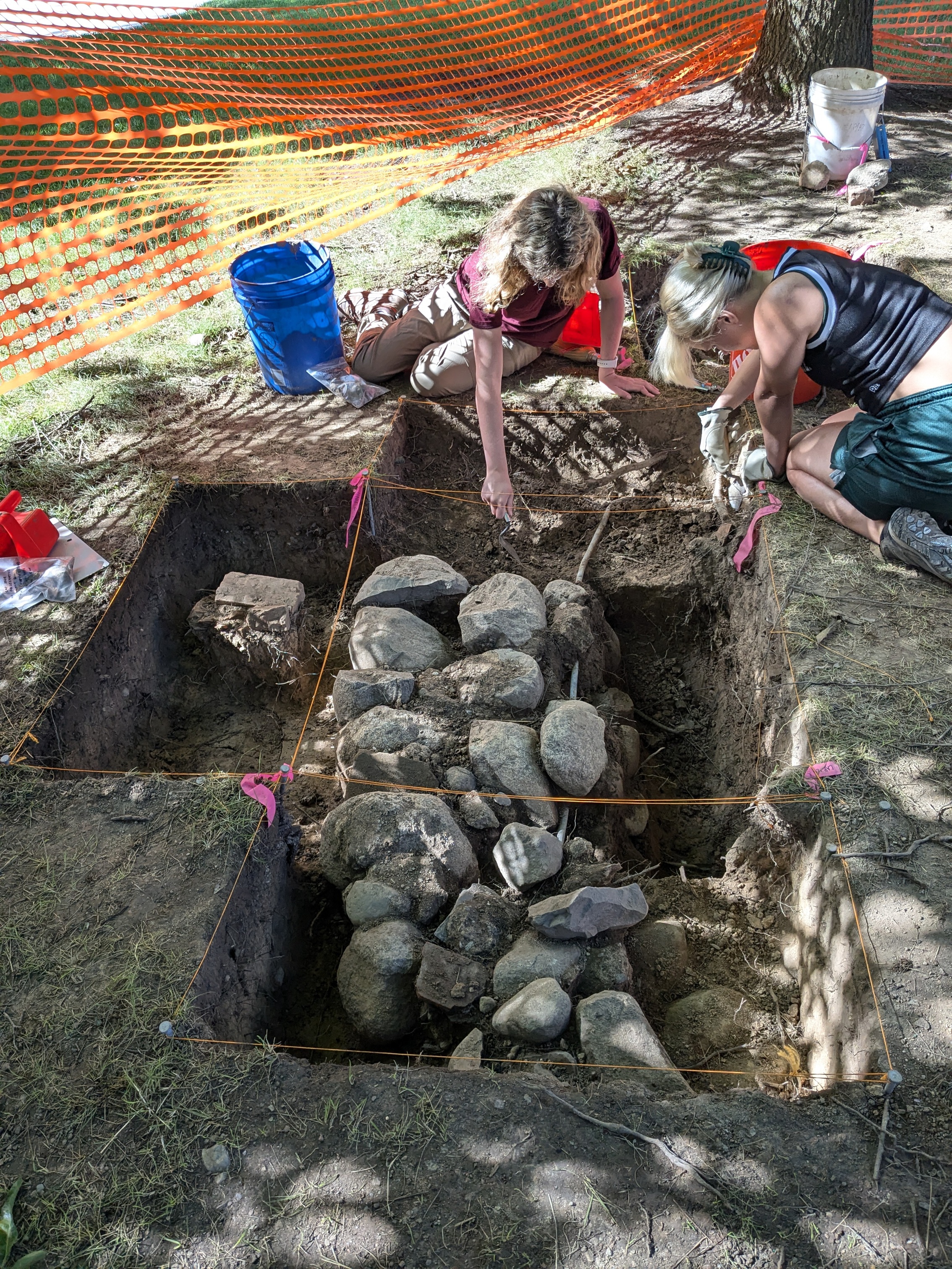
• Portions of the stone foundation were systematically excavated, as seen in the following photo.
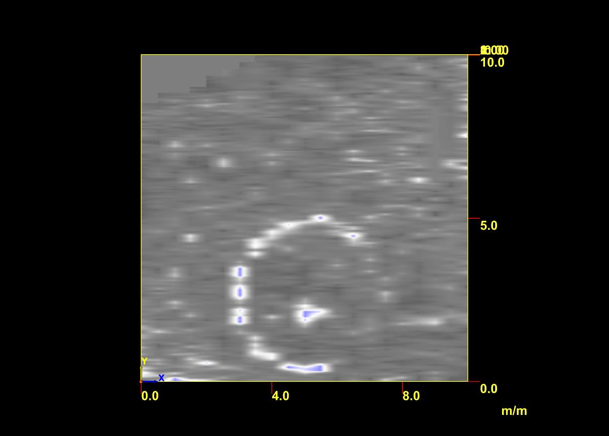
• The entire area was mapped with Magnetrometry, with the circular foundation clearly visible in the results.
Who would have thought one of MSU's first science facilities - an observatory meant to observe the sky - would become a living labratory for a completely different field of science - archaeology - well over a century later? The MSU observatory was built in 1881, but was torn down in the 1920s. Over time, its exact location was forgotten, until now. Learn more about the rediscovery.
Water: Exploring the Depths
Underwater Archaeologists use geophysical technologies to see below the water. Magnetometers and metal detectors can be used to locate sites/objects underwater. Sonar is a common geophysical technology used by underwater archaeologists. Sonar makes finding, and exploring, shipwrecks easier. Sonar devices can either be pulled by a boat, or can be mounted to autonimous vehicles that scan a prescribed area.
• Emits sound waves that bounce off the lake bottom
• Measures the acoustic wave’s speed and density
• Creates highly detailed, 2-dimensional visual of underwater features, including:
◦ Shipwrecks
◦ Aircraft wrecks
◦ Submerged structures
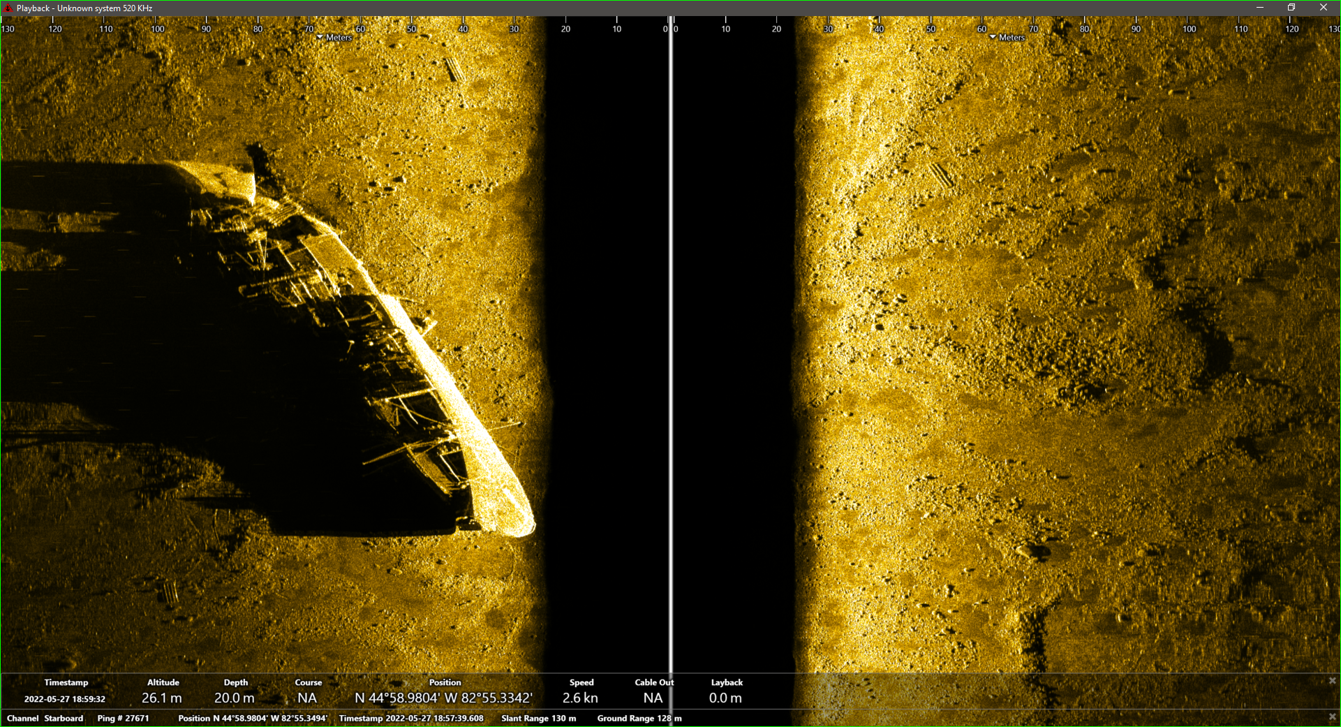
The ocean-going freighter Monrovia sank in Lake Huron near Alpena in 1959. It has been extensively documented using side scan sonar and other methods.
• Emits a fan-shaped swath of sound waves downward to map the lake floor
• Calculates how long the acoustic pings take to bounce back
• Generates a 3-dimensional bathymetry and detailed images, including:
◦ Underwater landscape features
◦ Submerged cultural resources
Recently, a multibeam sonar vessel mapped the lakebed under a large area of the Straits of Mackinac and areas around Mackinac Island.
The Great Lakes have been superhighways for millenia. As many as 6,000 ships have been lost on the Great Lakes, including an estimated 1,500 in Michigan waters. The preservation of shipwrecks is important so archaeologists can better understand the lifeway of the people who built, operated, and went down with the ship. The Monrovia, a 448-foot long ocean-going ship that sank in Lake Huron near Alpena in 1959, has been extensively studied using side scan sonar.
See a side scan sonar image of the MonroviaAir: Drones open new Doors
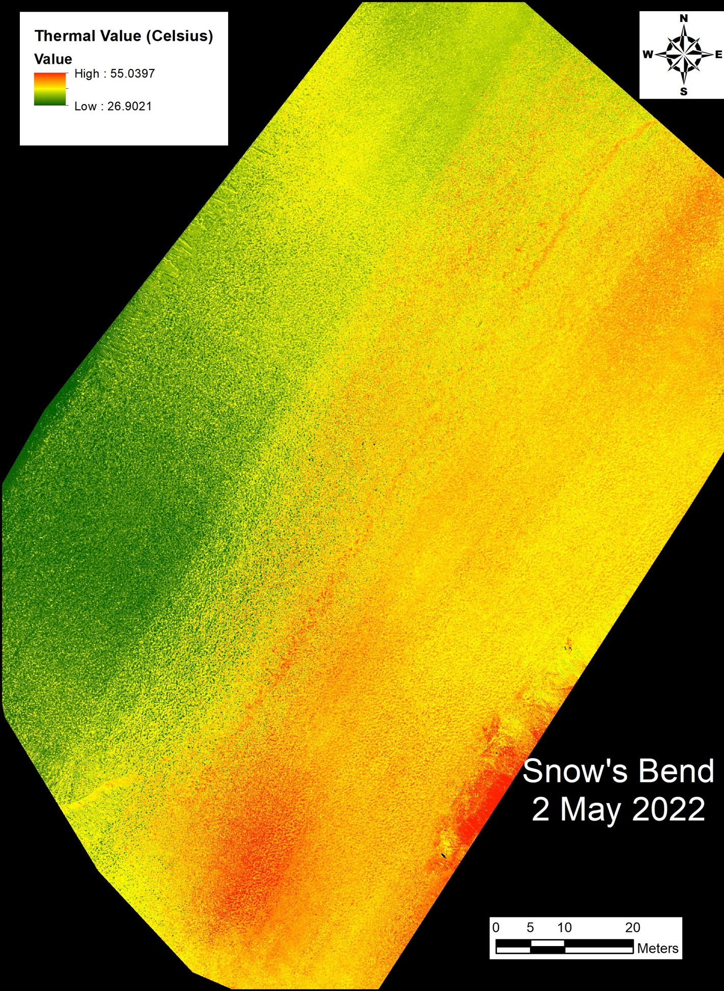
Geophysical technologies can also be attached to drones to get a large-scale picture of the area; digitally mapping terrain features to identify cultural elements hidden beneath vegetation or the water.
LiDAR
LiDAR (Light Detection and Ranging) is able to make high-resolution models of the ground and lake bottoms. A laser scanner transmits brief pulses of light to the ground surface, which when reflected back, measure the distance between the scanner and the ground.
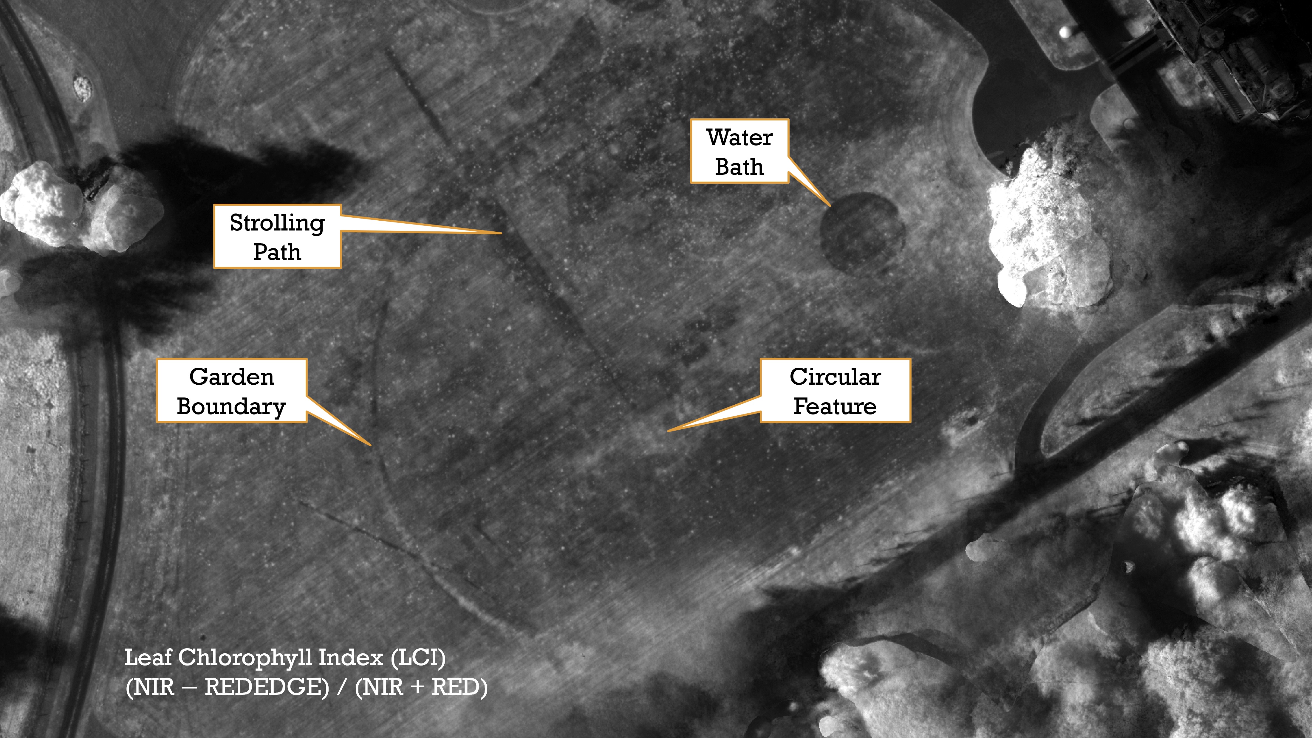
Multispectral drone imagery is useful for detecting archaeological features by sensing differences in vegetation patterns that are invisible to the naked eye. This image shows the subsurface archaeological remains of a seventeenth century formal garden in Normandy, France.
Thermal drone imagery is useful for detecting the presence of archaeological materials by sensing differences in ground temperature. This image shows the presence of both known and suspected archaeological features in west-central Alabama. The red areas suggest the presence of archaeological materials through higher thermal saturation shown in red.
Why Archaeologists Use Multiple Methods
No single technique works perfectly in every environment. Setting, soil type, moisture, depth, and the material being investigated all effect survey results. Archaeologists often combine several geophysical methods to create a more complete and accurate picture of what lies beneath the surface before deciding where—or whether—to excavate.
• Preserves sites by minimizing excavation and preventing unnecessary damage.
• Locates buried features in advance, making excavations targeted and efficient.
• Saves time and money by surveying large areas quickly.
• Creates detailed maps of underground features, helping archaeologists understand how ancient settlements were organized.
• Protects culturally significant locations, including cemeteries and sacred sites, by reducing or meliminating disturbance.
• Supports long-term conservation by allowing researchers to study sites while leaving them intact for future generations, improved technologies, or for sites that must remain undisturbed.
Archaeology 101
Michigan Archaeology Day | Michigan History Center
Michigan State Historic Preservation Office (SHPO)
Archaeology Program | Michigan SHPO
Archaeology Laws | U.S. National Park Service
National Historic Preservation Act of 1966 | U.S. National Park Service
Underwater Archeology | U.S. National Park Service
Archaeology Projects in Michigan | Field Schools & Dig Sites
"Artifacts reveal the human side of lighthouse life" | Spartan Newsroom
Fort Gratiot Lighthouse Historic Structures Report | Quinn Evans Architects
Great Lakes Mapping and the research vessel Echo | U.S. National Park Service
How to Report a Shipwreck Discovery in Michigan | Michigan SHPO
Learn about LiDAR: Knowledge Written in Stone | Michigan SHPO
"Lighthouses shine for archaeologists" | Great Lakes Echo
For this year's poster, we thank our partners: the Michigan Department of Natural Resources, Oakland University, St. Clair County Parks, and the USDA-Natural Resources Conservation Service. Learn more about their respective programs at the links below.
Underwater Preserves | Michigan Department of Natural Resources
Anthropology & Archaeology | Oakland University
Visit the Fort Gratiot Light Station | St. Clair County Parks
Cultural Resources Program | USDA-Natural Resources Conservation Service